Mapping the Modern Agora

The Mapping the Modern Agora project at the SNF Agora Institute is a pioneering effort to harness the power of advanced computational social science tools to map the landscape of civic infrastructure across America.
This innovative project seeks to understand and visualize the modern agora — the dynamic public spaces that foster public discourse and collective action — by mapping civic infrastructure in the United States.
At a time when America’s civic spaces are at risk of diminishing, the Mapping the Modern Agora project is more relevant than ever. Its goals extend beyond merely assessing the current state of civic infrastructure; the project also aspires to understand the conditions needed to support and sustain democracy in communities and to drive targeted initiatives that reinforce and enrich American democratic life, ensuring that civic interaction remains a cornerstone of the nation’s political landscape.
The MapAgora Dashboard
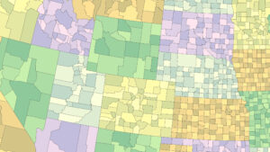
The MapAgora Dashboard is an interactive site that visualizes the availability, composition, and equity of civic opportunities across U.S. counties. This dashboard presents only a subset of the full MapAgora datasets. It includes county-level aggregates of civic opportunity counts and organizational types, plus interactive visualizations of these county-level measures. View county-level civic opportunity scores, see how each place ranks, and examine the types of organizations driving civic access across America.
Related Resources
Goals For Healthy American Agoras
-
Provide detailed maps of civic infrastructure, from libraries and nonprofits to community organizations and parks, and the civic opportunities those entities provide.
-
Develop a nuanced classification scheme for civil society organizations, facilitating a deeper understanding.
-
Catalyze new lines of scholarly inquiry through previously unavailable datasets that provide a holistic view of America's civic spaces.